
Fripp Township
8 priority targets. Zero drilled in 47 years.
Abitibi Greenstone Belt · NTS 42A/06 SW + 42A/03 NW · ~49 km SE of Timmins
Overview
Fripp Township — 8 priority targets. Zero drilled in 47 years.
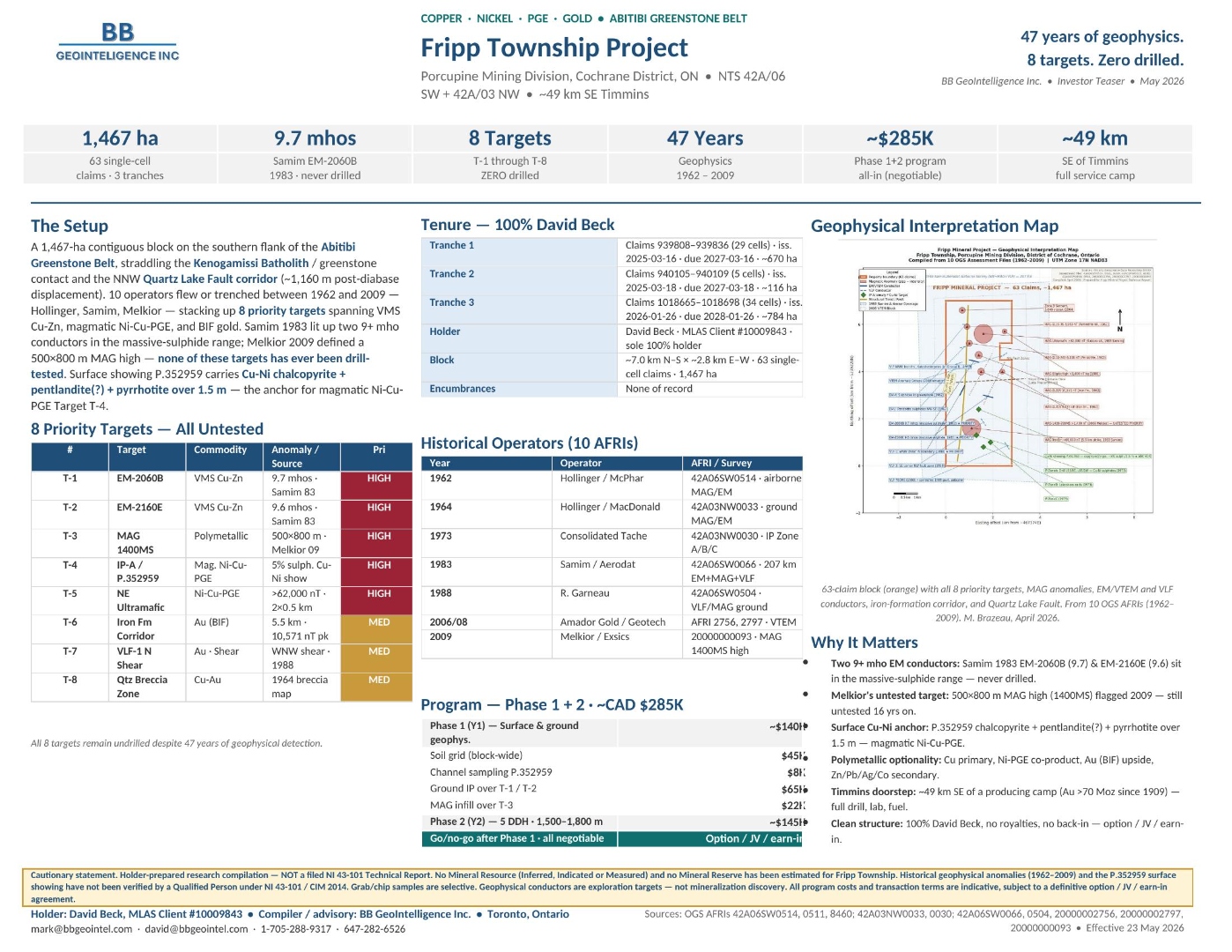
1,467 ha contiguous block on the southern flank of the Abitibi Greenstone Belt with 8 priority Cu-Ni-PGE/Au targets — none ever drilled despite 47 years of geophysical detection.
Summary
Within the Abitibi Greenstone Belt. Commercial structure (option, JV, earn-in, royalty, work commitment) is open and negotiable; a full data room is available on request.
Property Setting
A 1,467-ha contiguous block on the southern flank of the Abitibi Greenstone Belt, straddling the Kenogamissi Batholith / greenstone contact and the NNW Quartz Lake Fault corridor (~1,160 m post-diabase displacement). 10 operators flew or trenched between 1962 and 2009 — Hollinger, Samim, Melkior — stacking up 8 priority targets spanning VMS Cu-Zn, magmatic Ni-Cu-PGE, and BIF gold.
Samim 1983 lit up two 9+ mho EM conductors in the massive-sulphide range; Melkior 2009 defined a 500×800 m MAG high — none of these targets has ever been drill-tested. Surface showing P.352959 carries Cu-Ni chalcopyrite + pentlandite(?) + pyrrhotite over 1.5 m — the anchor for magmatic Ni-Cu-PGE Target T-4.
Headline Data & Targets
Selected on-claim values, prioritized targets and supporting source files. All grades quoted are historical and indicative; see the cautionary statement at the bottom of this page.
| # | Target | Commodity | Anomaly / Source | Pri |
|---|---|---|---|---|
| T-1 | EM-2060B | VMS Cu-Zn | 9.7 mhos · Samim 83 | HIGH |
| T-2 | EM-2160E | VMS Cu-Zn | 9.6 mhos · Samim 83 | HIGH |
| T-3 | MAG 1400MS | Polymetallic | 500×800 m · Melkior 09 | HIGH |
| T-4 | IP-A / P.352959 | Mag. Ni-Cu-PGE | 5% sulph. Cu-Ni showing | HIGH |
| T-5 | NE Ultramafic | Ni-Cu-PGE | >62,000 nT · 2×0.5 km | HIGH |
| T-6 | Iron Fm Corridor | Au (BIF) | 5.5 km · 10,571 nT pk | MED |
| T-7 | VLF-1 N Shear | Au · Shear | WNW shear · 1988 | MED |
| T-8 | Qtz Breccia | Cu-Au | 1964 breccia map | MED |
Geology & Mineralization
Fripp Township lies within the Abitibi Greenstone Belt, on map sheet NTS 42A/06 SW + 42A/03 NW, in the ~49 km SE of Timmins corridor. The setting and host stratigraphy are described in the Property Setting section above; the controlling structures, host lithologies and known mineralized horizons referenced in Headline Data are summarised here for technical readers.
Host stratigraphy
A 1,467-ha contiguous block on the southern flank of the Abitibi Greenstone Belt, straddling the Kenogamissi Batholith / greenstone contact and the NNW Quartz Lake Fault corridor (~1,160 m post-diabase displacement). 10 operators flew or trenched between 1962 and 2009 — Hollinger, Samim, Melkior — stacking up 8 priority targets spanning VMS Cu-Zn, magmatic Ni-Cu-PGE, and BIF gold.
Source materials
OGS AFRIs 42A06SW0514, 0511, 8460; 42A03NW0033, 0030; 42A06SW0066, 0504, 20000000093, 20000002797, 20000000093. Effective 23 May 2026.
Tenure & Holder
Recommended Programme
Phased exploration programme designed for a third-party operator, prospector partner or junior under option / JV / earn-in. Indicative budget; all line items are negotiable.
| Phase 1 (Y1) — Surface & ground geophys. | ~$140k |
| Soil grid (block-wide) | $45k |
| Channel sampling P.352959 | $8k |
| Ground IP over T-1 / T-2 | $65k |
| MAG infill over T-3 | $22k |
| Phase 2 (Y2) — 5 DDH · 1,500–1,800 m | ~$145k |
| Go/no-go after Phase 1 · all negotiable | Option / JV / earn-in |
Why It Matters
Two 9+ mho EM conductors
Samim 1983 EM-2060B (9.7) & EM-2160E (9.6) sit in the massive-sulphide range — never drilled.
Melkior's untested target
500×800 m MAG high (1400MS) flagged 2009 — still untested 16 years on.
Surface Cu-Ni anchor
P.352959 chalcopyrite + pentlandite(?) + pyrrhotite over 1.5 m — magmatic Ni-Cu-PGE.
Polymetallic optionality
Cu primary, Ni-PGE co-product, Au (BIF) upside, Zn/Pb/Ag/Co secondary.
Timmins doorstep
~49 km SE of a producing camp (Au >70 Moz since 1909) — full drill, lab, fuel.
Clean structure
100% held, no royalties, no back-in — option / JV / earn-in / sale.
Cautionary Statement
Toronto, Ontario · BB GeoIntelligence Inc.
Interested in Fripp Township?
Option, JV and earn-in terms are all negotiable. We can package a full data room with AFRI compilation, drill database, structured GIS and (where applicable) NI 43-101 supporting materials.