
Bilton-Brown Copper
High-grade historical Cu deposit. Two untested EM targets.
Ontario Huronian Belt · NTS 41J/06 · Sault Ste. Marie Mining Division
Overview
Bilton-Brown Copper — High-grade historical Cu deposit. Two untested EM targets.
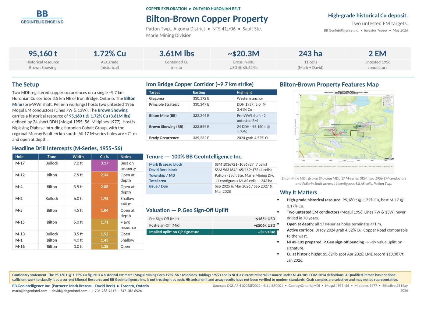
Two MDI-registered copper occurrences on a single ~9.7 km Huronian Cu corridor 3.5 km NE of Iron Bridge, Ontario — historical resource of 95,160 t @ 1.72% Cu (3.61M lbs) and two untested 1956 EM conductors.
Summary
Within the Ontario Huronian Belt. Commercial structure (option, JV, earn-in, royalty, work commitment) is open and negotiable; a full data room is available on request.
Property Setting
Two MDI-registered copper occurrences on a single ~9.7 km Huronian Cu corridor 3.5 km NE of Iron Bridge, Ontario. The Bilton Mine (pre-WWI shaft, Pellerin workings) hosts two untested 1956 Mogul EM conductors (Lines 7W & 13W). The Brown Showing carries a historical resource of 95,160 t @ 1.72% Cu (3.61M lbs) defined by 24 short DDH (Mogul 1955–56, Midpines 1977).
Host is Nipissing Diabase intruding Huronian Cobalt Group, with the regional Murray Fault ~6 km south. All 17 M-series holes are <71 m and open at depth.
Headline Data & Targets
Selected on-claim values, prioritized targets and supporting source files. All grades quoted are historical and indicative; see the cautionary statement at the bottom of this page.
| Hole | Zone | Width | Cu % | Notes |
|---|---|---|---|---|
| M-17 | Bullock | 7.0 ft | 3.17 | Best on property |
| M-12 | Bilton | 7.5 ft | 2.34 | Open at depth |
| M-4 | Bilton | 5.5 ft | 2.08 | Open at depth |
| M-2 | Bullock | 6.0 ft | 1.95 | Shallow <40 m |
| M-5 | Bilton | 4.5 ft | 1.84 | Open at depth |
| M-15 | Bilton | 5.0 ft | 1.71 | = avg resource |
| M-13 | Bullock | 3.5 ft | 1.52 | Open |
| M-1 | Bilton | 4.0 ft | 1.43 | Shallow |
| M-16 | Bilton | 3.0 ft | 1.38 | Open |
Geology & Mineralization
Bilton-Brown Copper lies within the Ontario Huronian Belt, on map sheet NTS 41J/06, in the Sault Ste. Marie Mining Division corridor. The setting and host stratigraphy are described in the Property Setting section above; the controlling structures, host lithologies and known mineralized horizons referenced in Headline Data are summarised here for technical readers.
Host stratigraphy
Two MDI-registered copper occurrences on a single ~9.7 km Huronian Cu corridor 3.5 km NE of Iron Bridge, Ontario. The Bilton Mine (pre-WWI shaft, Pellerin workings) hosts two untested 1956 Mogul EM conductors (Lines 7W & 13W). The Brown Showing carries a historical resource of 95,160 t @ 1.72% Cu (3.61M lbs) defined by 24 short DDH (Mogul 1955–56, Midpines 1977).
Source materials
OGS AF 41O06SE0022 · 41J11SE0001 · GeologyOntario MDI · Mogul 1955–56 · Midpines 1977 · Effective 23 May 2026
Tenure & Holder
Recommended Programme
Phased exploration programme designed for a third-party operator, prospector partner or junior under option / JV / earn-in. Indicative budget; all line items are negotiable.
| Pre-Sign-Off (Mid valuation) | ~$165k USD |
| Post-Sign-Off (Mid valuation) | ~$506k USD |
| Implied uplift on QP signature | ~3× value |
Why It Matters
High-grade historical resource
95,160 t at 1.72% Cu, best M-17 at 3.17% Cu.
Two untested EM conductors
Mogul 1956, Lines 7W & 13W — never drilled in 70 years.
Open at depth
All 17 M-series holes terminate <71 m.
Active corridor
Brady 2024 grab 4.52% Cu; Copper Road comparable to the west.
NI 43-101 in progress
P.Geo sign-off pending → ~3× value uplift on signature.
Cu at historic highs
$5.62/lb spot Apr 2026; LME record $13,387/t Jan 2026.
Cautionary Statement
Toronto, Ontario · BB GeoIntelligence Inc.
Interested in Bilton-Brown Copper?
Option, JV and earn-in terms are all negotiable. We can package a full data room with AFRI compilation, drill database, structured GIS and (where applicable) NI 43-101 supporting materials.